 Ship Inspection
Smart Pilot Plug and Remote GPS – From Prototype to Working Field System
Disclaimer
The Smart Pilot Plug Project is an experimental xShipX Lab technical project. It is not certified navigation equipment and is not intended to replace approved ship navigation systems, official pilotage equipment, bridge instruments, ECDIS, radar, AIS, GNSS receivers, gyrocompass, or other required onboard systems.
All information from this system should be treated as an additional situational-awareness aid only. Navigation decisions must always be based on approved equipment, professional judgement, official procedures, and the actual conditions onboard.
The project is shared as a practical field-tested development log. Hardware, software, sensor calibration, data handling, and user interface details may continue to change as testing and improvements continue.
From experiment to working field system
The Smart Pilot Plug Project has reached an important stage: the system is now working in real operating conditions and delivering the information it was designed to provide.
Like any practical technical project, it may still need adjustments, refinements, cosmetic improvements, enclosure improvements, and future software updates. But the main concept has now been proven in real use.
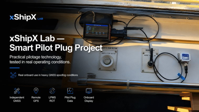
A portable pilot-focused system can combine pilot plug data, independent GNSS, remote GPS streaming, ROT sensor data, and onboard status monitoring into one practical tool for real pilotage conditions.
The project is no longer only a bench experiment. It has become a working field system.
The practical problem
During pilotage, reliable movement information is essential.
Position, speed over ground, course over ground, heading, rate of turn, and AIS/NMEA data all help create a clear understanding of what the vessel is doing.
In normal conditions, this information usually comes from ship systems, bridge equipment, portable pilot units, or the pilot plug.
But real operating conditions are not always normal.
GNSS reception inside the bridge can be poor. Heated bridge windows, ship structure, antenna placement, multipath, or signal interference can reduce reliability. In areas affected by GNSS spoofing or jamming, ship GPS data may become unreliable, unstable, or unavailable.
This creates a practical need for an independent backup data path.
The Smart Pilot Plug Project was developed around this question:
Can a portable pilot-focused system continue to provide useful movement awareness when normal data sources become unreliable?
The current answer from field testing is: yes.
Smart Pilot Plug concept
The Smart Pilot Plug system was developed as a portable pilotage awareness platform.
Its purpose is not to replace certified navigation equipment. Its purpose is to provide an additional practical layer of movement awareness when normal data sources are incomplete, delayed, unavailable, or affected by interference.
The system combines several functions:
- pilot plug and AIS/NMEA data handling;
- independent GNSS positioning;
- remote GPS input from an outside antenna location;
- LPMS-based ROT and heading sensor experiments;
- local onboard display for quick system status;
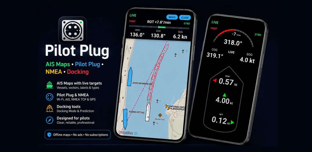
- Wi-Fi output to a tablet application;
- future spoofing, jump-warning, and RTK-related improvements.
The main idea is simple: if one source is weak or unavailable, the system should still provide useful movement information from another independent source.
Remote GPS mode
One of the most important parts of the project is Remote GPS Mode.
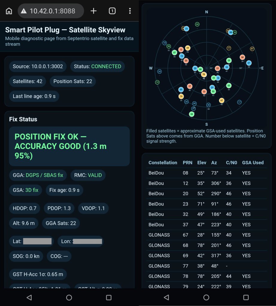
The best GNSS reception is often not inside the bridge. A better signal may be available outside, near a suitable window, on the bridge wing, or in another position where the antenna has a clearer view of the sky.
Remote GPS Mode allows an external GNSS source to be placed in a better reception position while the main Smart Pilot Plug system remains available near the working position.
This creates a useful separation:
- the GNSS receiver and antenna can be placed where reception is best;
- the Smart Pilot Plug system can remain near the operator;
- the tablet application can receive the final navigation stream over Wi-Fi.
This approach has proved especially valuable in difficult GNSS conditions. In heavy spoofing or poor ship-GPS conditions, the independent outside GNSS path can still provide usable movement information when ship-side GPS data is weak or unavailable.
Technical hardware notes
The Smart Pilot Plug system is built around selected components normally used in demanding positioning, robotics, industrial, and autonomous-system applications.
This is one of the reasons the system has become useful in real pilotage conditions instead of remaining only a simple visual demonstration.
Septentrio mosaic-X receiver platform
The independent GNSS part of the system is based on a Septentrio mosaic-X receiver platform.
The receiver platform provides high-performance multi-constellation GNSS capability, professional data interfaces, NMEA output support, interference awareness features, and Galileo OSNMA support in compatible configurations.
For the Smart Pilot Plug Project, the most important value is not only maximum laboratory accuracy. The practical value is resilience.
The GNSS source can be placed with a better antenna view and used as an independent data path when ship-side GPS data is weak, unavailable, or affected by interference.
OSNMA and GNSS trust
Galileo OSNMA, or Open Service Navigation Message Authentication, is an important development for GNSS resilience.
OSNMA allows compatible receivers to authenticate Galileo navigation message data and helps confirm that the received navigation message has not been modified.
This does not mean that spoofing risk disappears completely. GNSS interference is a complex subject, and real operational conditions can still be difficult.
However, OSNMA is a major step toward stronger civilian GNSS trust, especially when it is combined with:
- good antenna placement;
- multi-constellation tracking;
- receiver interference monitoring;
- independent position sanity checks;
- comparison with ship movement, AIS/NMEA, heading, COG, SOG, and ROT behavior.
For the Smart Pilot Plug Project, OSNMA is interesting because the system is already focused on the same practical problem: how to maintain useful pilotage awareness when normal GNSS confidence is reduced.
LPMS-IG1 inertial sensor
The ROT and heading experiment uses an LPMS-IG1 industrial inertial sensor.
The LPMS-IG1 is not just a simple low-cost motion sensor. It is an industrial IMU in a waterproof metal housing, designed to output real-time calibrated sensor data, angular velocity, orientation data, Euler angles, quaternion data, and temperature information.
In the Smart Pilot Plug system, the most important LPMS value is direct angular velocity output.
Instead of calculating rate of turn only from heading changes over time, the system can use direct angular velocity from the sensor. This gives a very responsive rate-of-turn indication during manoeuvring.
Some calibration and fine adjustment may still be improved in the future, as with any sensor-based system. But field testing has already shown that direct LPMS-based ROT is highly useful for real pilotage awareness.
LPMS ROT result
Rate of turn is one of the most important values during manoeuvring, docking, turning, and close-quarters pilotage.
The project tested LPMS angular velocity data as a direct ROT source.
The result has been very promising. In real onboard use, the LPMS-based ROT response has shown strong practical value because it is independent from ship heading-delta calculations and can react directly to vessel rotation.
This is an important result for the project.
The system can deliver a responsive ROT indication even when normal ship data is incomplete, delayed, or not available in the desired form.
The current working version may still be refined, but it already delivers the practical information it was designed to provide.
Onboard display
The onboard display became more important than originally expected.
A local screen gives immediate confirmation that the system is alive and receiving useful data. Before opening any tablet application, the operator can quickly check basic system status such as GNSS, ship data, ROT, source status, and connection state.
This is a practical improvement because a portable system must not only work internally. It must also clearly show when it is working.
The display turns the device from a hidden data box into an understandable field tool.
Field-tested result
The Smart Pilot Plug system has now moved beyond the basic prototype stage.
In real onboard use, the system has delivered useful pilotage data during difficult GNSS conditions, including situations where ship-side GPS data was not usable.
The working setup combines:
- independent GNSS;
- outside antenna placement;
- remote GPS streaming;
- pilot plug and AIS/NMEA handling;
- direct LPMS angular-velocity ROT;
- onboard status display;
- Wi-Fi output to the tablet application.
The key achievement is simple:
The system now delivers what it was designed to deliver — independent, useful, pilot-focused movement information when reliable data matters most.
What may still improve
Development does not stop because the system works.
Future improvements may include:
- cleaner user interface design;
- improved enclosure and cable management;
- refined sensor calibration;
- additional GNSS reliability checks;
- position jump and spoofing warning logic;
- RTK reference station experiments;
- further long-term testing on different vessels and in different conditions.
These are normal improvements for any field-tested technical project.
The important point is that the core system is no longer only theoretical. It works, it is usable, and it has already shown real operational value.
Why this matters
The Smart Pilot Plug Project is not about creating another screen with numbers.
It is about building an independent practical data path.
In normal conditions, this gives additional confidence. In difficult conditions, it can become much more valuable.
When ship GPS is weak, when bridge reception is poor, when GNSS interference is present, or when pilot plug data is incomplete, a portable independent system can help maintain situational awareness.
That is the reason this project exists.
Conclusion
The Smart Pilot Plug and Remote GPS system has reached a strong working stage.
It started as a practical question:
Can a portable pilot-focused system provide useful backup awareness when normal navigation data becomes unreliable?
The current field-tested answer is yes.
There will still be adjustments, improvements, and new ideas. But the foundation is proven: independent GNSS, remote GPS, pilot plug data handling, LPMS ROT, and onboard status monitoring can work together as a compact practical system for real pilotage conditions.
This is the purpose of the Smart Pilot Plug Project — not to replace existing navigation systems, but to add a useful, independent, field-tested layer of awareness where it is needed most.