 Ship Inspection
Monitoring the Strait of Hormuz with Pilot Plug – Offline Maps and a Local AIS Wi-Fi Station
The Strait of Hormuz is one of the world’s most important and demanding maritime passages. Dense commercial traffic, restricted maneuvering room, high vessel concentrations and the possibility of unreliable communications or GNSS make independent situational awareness particularly valuable.
A useful monitoring system does not necessarily require an expensive bridge installation or a permanent internet connection.
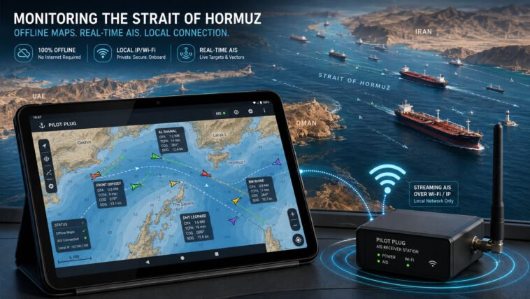
With the Pilot Plug app, an Offline Reference Map, and a small AIS receiver capable of streaming AIS data over Wi-Fi/IP, a mariner can create a completely local vessel-monitoring system that continues to operate even when internet access is unavailable.
A Simple Three-Part System
The concept consists of three components:
1. Pilot Plug Android app
The Pilot Plug app acts as the portable display.
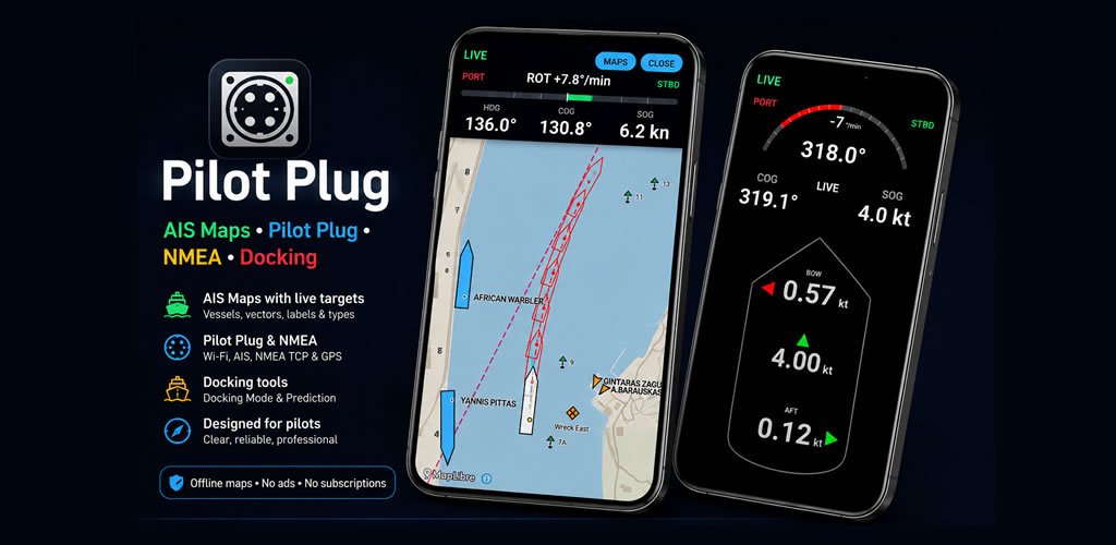
It can receive AIS/NMEA information over an IP network and display surrounding AIS targets on an Android phone or tablet.
Depending on the available data and operating mode, the app can provide information such as:
- Vessel position
- Course over ground
- Speed over ground
- Heading
- AIS vessel targets
- Vessel names and dimensions when transmitted
- Target vectors
- AIS trails
- Relative traffic monitoring
- CPA/TCPA information
- Distance and bearing measurements
The tablet therefore becomes a convenient local AIS display that can be carried to the bridge wing, chart room, office or another position within Wi-Fi range.
2. Offline Reference Map
Internet-based maps are useful, but they should not be assumed to be available everywhere.
For an area such as the Strait of Hormuz, an Offline Reference Map can be stored directly on the Android device.
Once downloaded and imported into Pilot Plug, the reference map does not require an internet connection for normal use.
The map provides geographic context while AIS targets are received separately from the local AIS station.
This is an important distinction:
The map and the AIS data are independent.
The Offline Reference Map provides the background.
The AIS receiver provides the live ships.
The Pilot Plug app combines them on the Android display.
This means the system can continue functioning on a vessel even when there is:
- No mobile-data coverage
- No Starlink connection
- No shore Wi-Fi
- No access to an online AIS service
The system is therefore particularly suitable for ships that want their own local traffic picture rather than depending entirely on internet-based vessel-tracking websites.
3. A Simple AIS Wi-Fi Station
The AIS station itself can be very simple.
At minimum it requires:
- AIS receiver
- VHF AIS antenna
- Small computer or network interface
- Wi-Fi access point
- Power supply
The AIS receiver listens to the normal maritime AIS channels and receives messages transmitted by nearby vessels.
Instead of uploading those messages to the internet, the station can make the AIS stream available locally through the vessel’s own Wi-Fi network.
For example:
AIS antenna → AIS receiver → local processor → Wi-Fi → Pilot Plug
The receiver or small computer can expose the AIS stream using a normal TCP/IP connection.
For example:
192.168.4.1 : 10110
A Pilot Plug tablet connected to the same Wi-Fi network can then connect directly to that IP address and port.
AIS messages such as:
!AIVDM,...
are received by the app and converted into visible targets on the map.
No cloud server is required.
No internet connection is required.
Private AIS Monitoring
There is another advantage to this architecture: privacy.
Many AIS receiving stations automatically forward received traffic to public AIS networks.
That can be useful, but it is not necessary for a private shipboard monitoring system.
A dedicated local AIS station can be configured so that:
AIS comes in, but nothing automatically goes out to the internet.
The station simply distributes the received AIS data to authorized devices on the local Wi-Fi network.
For example:
AIS antenna
↓
AIS receiver
↓
Private Wi-Fi
↓
Pilot Plug tablet
Nothing needs to be uploaded to an external server.
If desired, the station could also have an Ethernet port and connect to the ship’s local router.
The architecture could then become:
AIS Receiver → Ethernet Router → Ship Wi-Fi → Multiple Pilot Plug Devices
Several authorized phones or tablets could monitor the same AIS traffic simultaneously.
Connecting the system to a router does not have to mean sending AIS information to the internet. Local distribution and internet forwarding can remain completely separate functions.
Why This Is Useful in the Strait of Hormuz
In busy waters, having another independent way of observing traffic can be valuable.
Imagine a vessel approaching or transiting the Strait of Hormuz.
A tablet running Pilot Plug already contains the regional Offline Reference Map.
The ship’s small AIS station is operating nearby.
The tablet connects to:
PILOT-AIS Wi-Fi
and Pilot Plug connects to:
192.168.4.1:10110
Within seconds, surrounding AIS targets appear over the locally stored map.
The operator can move around the bridge while continuing to observe the traffic picture.
Because both the map and AIS feed are local, losing the internet connection does not remove the display.
One AIS Station – Several Displays
A major advantage of IP-based AIS distribution is that the receiver does not need to be connected physically to every display.
One AIS station can potentially supply several devices:
AIS Station
↙ ↓ ↘
Tablet 1
Tablet 2
Phone
This can be particularly useful on a vessel where navigation information is concentrated on the main bridge.
A captain, pilot or officer working from a bridge wing could carry an Android tablet while receiving the same local AIS stream over Wi-Fi.
Adding Own-Ship Navigation Data
The system can also be expanded.
AIS targets and own-ship navigation data do not necessarily have to originate from the same device.
For example, Pilot Plug may receive navigation data from a pilot plug, AIS/NMEA interface or suitable GNSS/NMEA source while simultaneously displaying external AIS targets.
This makes it possible to build a compact portable situational-awareness system consisting of:
- Own-ship position
- Heading
- Course and speed
- Rate of turn
- Nearby AIS vessels
- Target vectors and trails
- CPA/TCPA information
- Offline geographic reference
- Docking and maneuvering information when suitable data is available
All displayed on one Android tablet.
Independence Is the Main Idea
The purpose is not to replace ECDIS, radar or other approved bridge equipment.
The value comes from independence and portability.
Instead of requiring:
Internet → Remote AIS Server → Online Map → Tablet
the local system can work as:
VHF AIS Signals → Own AIS Receiver → Own Wi-Fi → Pilot Plug
while the map is already stored on the device.
That removes several external dependencies.
It also allows a vessel, pilot or maritime operator to build a monitoring system according to their own requirements rather than depending entirely on commercial online services.
Create a Reference Map for the Area You Need
Pilot Plug is not limited to one geographic region.
Offline Reference Maps can be prepared for the areas where the user actually operates.
A mariner working regularly between the Persian Gulf, Strait of Hormuz and Gulf of Oman could maintain the required reference maps on the tablet before departure.
The same principle can be applied anywhere:
- Strait of Hormuz
- Singapore Strait
- Bosporus
- English Channel
- Baltic Sea
- Port approaches
- Offshore terminals
- Anchorages
- Rivers and inland waterways
- Remote areas with poor internet connectivity
The map does not need to contain live information.
It provides the geographic reference while the AIS receiver supplies the changing traffic picture.
A Small Independent Maritime Monitoring System
The complete concept can therefore be surprisingly compact:
Android tablet running Pilot Plug
Pilot Plug Offline Reference Map
AIS receiver with VHF antenna
Wi-Fi/IP connection
=
A portable, local and internet-independent AIS monitoring station
It can be installed permanently on a vessel or built as a small portable system.
Most importantly, the owner controls where the AIS data goes.
It can remain completely local, be distributed through a private ship network, or – only when intentionally configured – be forwarded elsewhere.
For areas such as the Strait of Hormuz, where reliable access to navigation and traffic information is especially important, this provides another practical layer of independent situational awareness.
Important Safety Notice
Pilot Plug, Offline Reference Maps and locally received AIS information are intended as supplementary situational-awareness tools only.
They are not approved replacements for ECDIS, radar, official nautical charts, bridge navigation systems, collision-avoidance procedures, visual lookout or professional navigational judgment.
AIS information can be missing, delayed or incorrect, and vessels not transmitting AIS will not appear.
Always use approved navigational equipment and normal bridge procedures as the primary sources for safe navigation.