XShipX Navigation is an Android marine navigation app built for clear, reliable positioning and vessel awareness in coastal and port environments.
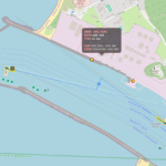
The app focuses on real-time navigation essentials, allowing users to see their own vessel position on a live map alongside surrounding marine traffic and chart data. Every element is designed to support situational awareness without unnecessary distractions.
![]()
Key Features
-
Live map-based marine navigation
-
Real-time vessel tracking and visualization for the Port of Klaipėda (additional ports planned)
-
Accurate GPS-based positioning
-
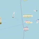
Course Over Ground (COG) averaging for stable heading display
-
Speed Over Ground (SOG) averaging for smooth speed indication
-
Clean, minimal interface optimized for navigation use
Why COG and SOG Averaging Matters
Raw GPS data can fluctuate due to signal noise, low speeds, or frequent position updates—especially in ports and confined waters.
XShipX Navigation applies intelligent averaging to COG and SOG values to present a more stable and realistic picture of vessel movement.
This results in:
-
Reduced heading jitter at low speeds
-
Smoother speed readouts during maneuvers
-
Improved situational awareness in busy or restricted areas
By focusing on averaged motion rather than momentary GPS spikes, XShipX Navigation helps users understand true vessel behavior with greater confidence.
Built with clarity and usability in mind, XShipX Navigation delivers stable, readable navigation data suitable for real-time marine awareness.
The app is designed as an informational and situational-awareness tool and is not intended to replace official navigation systems, certified ECDIS, paper charts, or professional bridge equipment.
 Get it on Google Play