Sailing a Real Ship From Your Browser
KlaipėdaTraffic.lt Simulator Mode and the KA-MOTION Prediction Engine
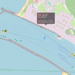
There’s a special moment in port when a ship stops being “a dot on a map” and becomes something alive.
A ferry is slow, almost stopped — and yet the bow keeps sliding, the stern answers late, the whole hull starts to swing on thrusters like it’s pivoting on an invisible pin. If you’ve ever watched that from a quay (or from a bridge wing with cold wind in your ears), you know why normal AIS maps often feel… wrong. The track line looks neat, but the ship’s behavior is missing.
That’s exactly the gap Simulator Mode on KlaipėdaTraffic.lt tries to fill.
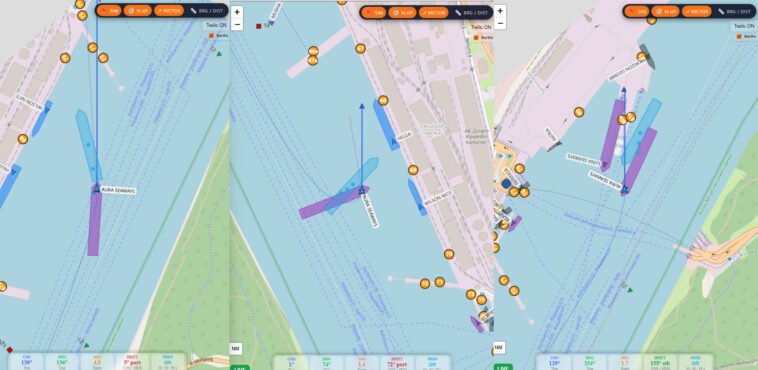
It’s a real-time visual tool where you can click a live AIS vessel and choose “Sail as this ship”, switching the map into a cockpit-style view: the vessel stays centered, the world moves around it, and you can see motion, heading, drift and short-term prediction in a way that resembles professional bridge displays more than typical public AIS websites.
What it actually shows (and why it feels “real”)
AIS broadcasts include dynamic fields like COG (Course Over Ground), SOG (Speed Over Ground), Heading, and Rate of Turn (when available). Most public AIS sites show position + a track, and maybe a straight projected line. That’s fine offshore. But inside a port — where ships go slow, rotate, drift, stop, go astern — the “dot and track” approach breaks the illusion.
Simulator Mode separates two things that are often mixed up online:
-
Where the ship is moving → COG / SOG
-
Where the ship is pointing → HDG
That one separation is the difference between watching a point slide and watching a vessel manoeuvre.
The prediction engine: KA-MOTION™
At the heart of the Simulator Mode is a dedicated prediction system:
KA-MOTION™
A short-horizon motion model designed specifically for port manoeuvres.
It generates prediction points at:
-
30 seconds
-
60 seconds
-
90 seconds
But here’s the important part: it’s not just “draw a line forward.”
K-MOTION™ is based on:
-
a rolling AIS history window
-
smoothed (but not cosmetically “delayed”) motion inputs
-
rate-of-turn aware prediction logic
-
vessel dimensions
-
centre-referenced geometry (prediction referenced to the vessel’s centre, not the AIS antenna point)
-
explicit handling for swinging in place and astern movement
This idea — using COG/ROT (and heading when present) to calculate projected motion — is aligned with how many marine systems treat AIS target vectors.
Forward, swing, astern — the hard parts that usually look wrong online
Forward
When moving ahead, Simulator Mode stays stable: motion follows COG, hull orientation follows HDG. It looks like what mariners expect: the ship moves one way, points another when there’s drift.
Swinging on thrusters / lines (near-zero speed)
This is where many public maps create “ghost movement.” A ship rotates, but the AIS point can appear to “walk” or orbit depending on antenna offset and smoothing.
Simulator Mode treats near-zero-speed behavior properly: the vessel rotates around its centre, so a pure swing looks like a swing — not a weird sideways slide.
Astern
Astern is the classic failure case online: the vector flips, the icon flips, the ship looks like it teleports into nonsense.
In Simulator Mode, astern is treated as it should be:
-
motion continues to follow COG
-
hull orientation stays consistent
-
no visual “flip” circus
Is there any other public website like this?
Big AIS platforms are extremely useful, but they’re primarily traffic viewers: heavy smoothing, delayed aggregation, and straight-line projections are common design choices at web scale.
A centre-referenced, heading-aware, manoeuvre-correct “sail as this ship” view is something we usually associate with professional systems (ECDIS / pilot units), not public websites.
So the honest statement is:
Among public AIS websites, this style of “bridge-like” motion visualization is rare — and we have not found another openly accessible site that offers the same combination of head-up, vessel-centre reference, swing handling, and astern-correct prediction in one tool.
If someone knows one, we’d genuinely like to compare and learn.
Why it’s useful (even if it’s “not for navigation”)
Simulator Mode isn’t meant to tell you what to do. It’s meant to help you understand what is happening.
People can use it for:
-
Ship officers / pilots (situational reference): quickly “read” traffic dynamics and manoeuvres visually
-
Students / cadets: learn the difference between heading and motion, and why drift exists
-
Researchers / developers: observe real AIS behavior in a confined-water environment
-
Port enthusiasts: enjoy realistic ship handling instead of teleporting icons
It’s also a reminder of something every mariner knows: a ship can be pointing one way and moving another — and that gap is where seamanship lives.
How to try it
-
Open the live map on KlaipėdaTraffic.lt
-
Click a vessel
-
Choose “Sail as this ship” (Simulator Mode)
-
Watch the relationship between:
-
COG vs HDG (drift)
-
rotation vs translation (swing vs motion)
-
prediction at 30/60/90 seconds
-
Transparency & disclaimer
All data is received from open AIS broadcasts. The simulator is a visual interpretation of that data — not a certified navigation system.
Not for navigation. For informational and educational purposes only.
Source: https://klaipedatraffic.lt/news/prediction_engine_ka_motion.html