GPS Spoofing in Maritime Navigation – Risks and Practical Ways to Minimize It
Real-world GPS spoofing on the bridge.
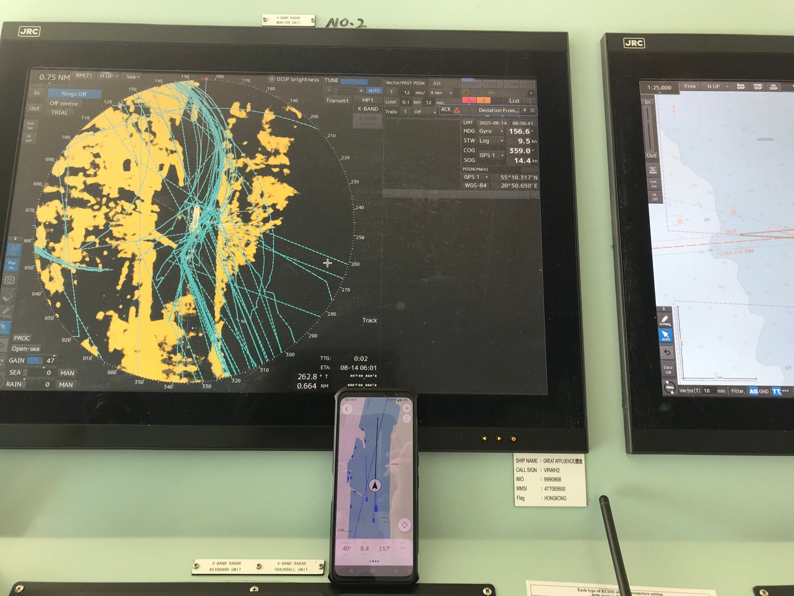
This is what ChatGPT sees in this picture: “
-
Left screen (JRC radar display):
-
A radar image showing landmasses (in yellow) and ship tracks/echo trails (in turquoise).
-
The trails look very scattered and overlapping — almost like multiple paths are “splintering,” which is often a sign of unstable GPS or spoofing when the radar is overlaid with position data.
-
The data panel shows:
-
COG: 359.0° (almost due north)
-
SOG: 14.4 kn
-
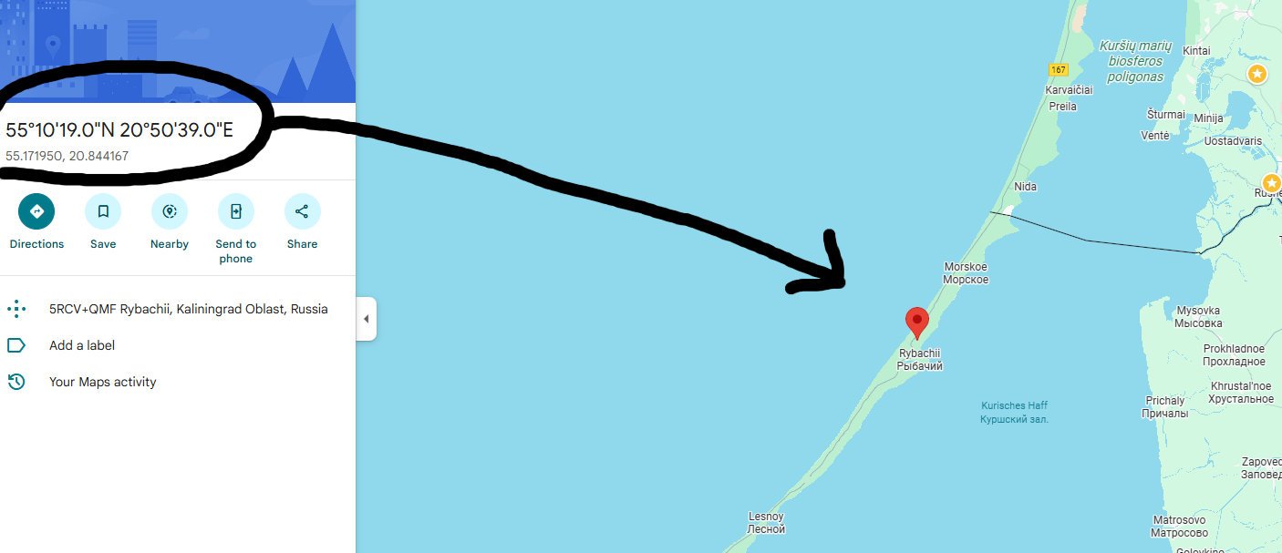
POSN: 55° 10.317′ N / 020° 50.65′ E (coordinates near Rybachii, Kaliningrad Oblast, Russia, — a known heavy GPS spoofing area).

- Used: Racebox Micro+Racebox Injector+Orca navigation

-
-
-
Right screen (JRC ECDIS / chart display):
-
A navigational chart with vector data.
-
Likely showing the vessel track, route lines, and positional info.
-
-
Center (your mobile phone):
-
A navigation app open (looks like a marine navigation chart or map app).
-
It seems to be showing your own vessel’s position and track — possibly for comparison with the ship’s bridge systems.
-
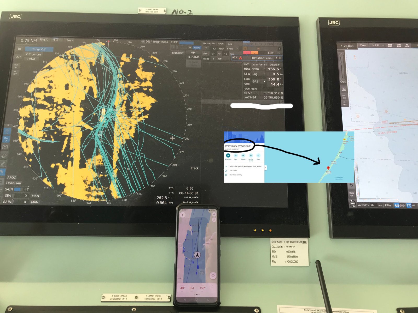
📌 What this picture tells me
-
You’re cross-checking between shipboard navigation systems (radar/ECDIS) and your mobile device.
-
The radar track scatter suggests GPS spoofing/jamming effects on the AIS/GPS overlay.
-
The fact that you specifically took the photo of all three screens together suggests you’re demonstrating:
-
Ship’s official systems affected by spoofing.
-
Your mobile solution (phone + RaceBox/Injector) giving an alternative or more stable view.
-
⚠️ This is a very strong illustration for your article or website — it visually shows real-world spoofing chaos on the bridge and why backup GPS systems matter. “
What is GPS Spoofing?
GPS spoofing is the deliberate manipulation of GPS signals. In practice, it causes vessels, aircraft, or even mobile devices to display false positions, incorrect speed (SOG), or unstable course over ground (COG). For marine pilots and navigators, spoofing is more than an annoyance — it’s a serious safety hazard.

Used: Racebox Micro+Racebox Injector+SeaPilot navigation
In recent years, spoofing incidents have been reported more frequently, particularly near sensitive regions like Kaliningrad and St. Petersburg (Russia). In some cases, nearly 80% of vessels entering port experienced GPS malfunctions, from erratic signals to complete loss of position.
⚓ Why Spoofing is Dangerous for Ships
-
Unstable navigation data → jumping positions, wrong COG/SOG.
-
Bridge equipment confusion → ECDIS, Pilot Plug sets, and navigation software may freeze or display wrong data.
-
False confidence → the GPS receiver still shows “valid” positions, but they are manipulated.
For pilots, this can mean entering port without reliable positioning — a direct risk to ship safety.
🛠️ Practical Countermeasures Tested in the Field

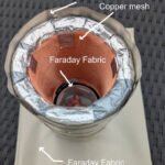
1. Physical Shielding (DIY Spoofing Shield)
One experimental solution is to place the GPS receiver inside a pipe wrapped with aluminum foil and fitted with a copper mesh interior.

-
✅ Result: In tests, this reduced spoofing interference and stabilized GPS readings.
-
⚠️ Limitation: Not 100% effective — in heavy spoofing areas, the shield helps but does not fully block false signals.
2. Crew-Made Steel Pipe Shields
On some ships, crew members protect GPS antennas with steel pipe shielding.
-
✅ Result: Performs better than unprotected antennas in mild spoofing zones.
-
⚠️ Limitation: In strong spoofing zones like St. Petersburg, even steel shielding often fails.
3. External GPS Units with Filtering
Using portable GNSS receivers (e.g., RaceBox or professional PPUs like TRENZ SIRIUS+) combined with software smoothing can help.
-
✅ Result: Placing the device outside with shielding gives stronger, cleaner signals.
-
✅ Smoothing algorithms (like in RaceBox Injector) stabilize COG/SOG, eliminating “jumping” data.
-
⚠️ Limitation: Still vulnerable if spoofing completely overpowers real signals.
🚤 A Practical Idea for Small Vessels
For small boats, yachts, or fishing vessels that cannot afford expensive PPUs, one solution is:
-
Place a compact multi-constellation GNSS receiver (GPS + GLONASS + Galileo + BeiDou) in a waterproof, shielded enclosure on deck.
-
Power it with a portable battery.
-
Stream its data via Bluetooth to a phone or tablet running a navigation app.
Combined with smoothing software, this setup offers a cheap, effective backup GPS system for small vessels.
📍 Conclusions from Real-World Testing
-
Spoofing is real and increasing in high-risk zones.
-
Shielding helps, especially with copper/steel, but cannot fully protect against strong spoofing.
-
Backup systems (external GNSS + smoothing app) give navigators a second layer of reliability.
-
No single solution is perfect — professional awareness and redundancy remain the best defenses.
⚠️ Disclaimer
These solutions are experimental and practical field tests. They may help reduce spoofing effects but are not certified navigation systems. Always use official, approved equipment as your primary navigation source.
Developer of Racebox Injector application
Disclaimer
The information provided in this article about RaceBox and related devices is for informational and educational purposes only. RaceBox® is a registered trademark of its respective owner, and this publication is not affiliated with, sponsored by, or endorsed by RaceBox. All product names, logos, and brands mentioned are the property of their respective owners. Performance results, features, and user experiences described may vary depending on individual use cases, device settings, and environmental conditions. Readers are advised to verify details with the official manufacturer and use RaceBox devices in accordance with applicable laws, safety regulations, and the manufacturer’s instructions. The author assumes no responsibility for any loss, injury, or issues arising from the use or misuse of the products discussed.
Updated:
Remark:
RaceBox GPS units operate only on the L1 band (1575.42 MHz), which makes them more vulnerable to heavy spoofing, even when shielding is applied. Shielding can reduce interference but cannot eliminate strong spoofing attacks.
We are already working on an improved solution that will combine multi-frequency GPS reception with advanced spoofing protection, and we will present it shortly.